A couple of recent Century Wood blog posts feature a shepherd’s hut in Devon and a cabin on a farm in northwest Illinois in the US. Each post has more about what else I did in the area, using these places as a base.


Hutters.uk – Iain's blog about hutting
Huts, cabins, sheds, and chalets
A couple of recent Century Wood blog posts feature a shepherd’s hut in Devon and a cabin on a farm in northwest Illinois in the US. Each post has more about what else I did in the area, using these places as a base.

One of ways people used to make huts for recreational use was to take a wooden railway wagon or carriage and rework it into a small building. Some of these still survive at hutting sites. Sometimes the same approach was used to make other buildings, and at the Blists Hill Victorian Town museum in Ironbridge is a tramcar that was turned into a Sunday school!

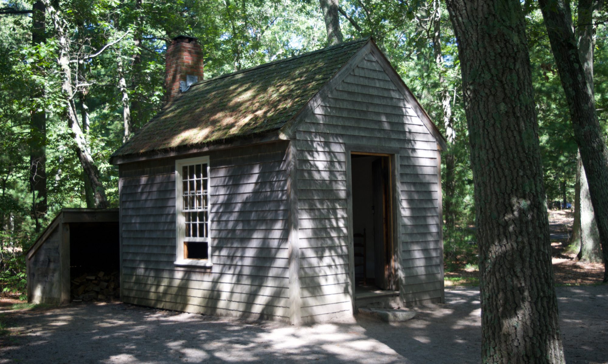
(I took the above photograph during our holiday at Century Wood this week.)

Yverdon-les-bains is an ancient spa town at the south end of Lake Neuchatel in Switzerland. Near the beach area (“la plage d’Yverdon”) on the bank of the small Buron river as it approaches the lake, are a row of chalets.
In style, they are very similar to plotland chalets and huts in Britain, but with some Swiss mountain cabin styling. Just as with the equivalent huts here, they are not holiday homes to let: they are places where families go at weekends and for holidays, perhaps for generations, often bodged together by their owners. With modern conveniences like satellite dishes, but also chimneys for wood stoves.
The following photographs were taken in the early summer of 2017.


Back in July 2014 when I started this blog, one of my first posts was about Jonathan Meades documentary “Severn Heaven” from 1990, in which he visited the Hill Farm chalet field next to the River Severn near Bewdley. Almost six years to the day I went there myself and it’s still much as it was when Meades filmed it.
There are bits of the film on YouTube and here’s one of the clips, showing the river and the chalets from the air, with Howard Davidson’s rather rousing music.

Back in the early summer of 1983, a young Iain McNab went to Broomlee Camp south of Edinburgh with most of his primary school class. They stayed there for a week, playing in the woods, being bussed into Edinburgh and off to Melrose Abbey, doing treasure hunts and an orienteering course around the grounds, and sleeping away from their families for the first time. It was also the first time I stepped into a wooden hut, never mind lived in one for a few days. A couple of years ago I visited on a damp April day just before they opened up for the season and took these photos.

The Broomlee Centre, as it now is, is one of the three Scottish Outdoor Education Centres, and first established in 1939 as part of a network of schools in the countryside for children evacuated from cities to escape bombing during the Second World War. After the war they were converted into residential education centres, used by schools and urban youth groups like the Scouts, as they still were when my school took us there.
Continue reading “Broomlee Camp”
Rudyard Lake in Staffordshire is an artificial lake created at the start of the 19th century to supply the canal network in the area. Once the railways arrived it became a popular destination for people from the surrounding cities, and has the feel of the Lake District.
 Along with boats for sailing and rowing, small pleasure steamers, and other water-side entertainments, the lake acquired hotels and guest houses. However, people also built huts and chalets on the banks of the lake and the surrounding hillsides.
Today the lake side is a mixture of public areas, farmland at the north end away from the busier “dam head” at the south, and modern cabins and chalets in private hands on long narrow plots from the lake to a road or bridleway – some of which can be rented for holidays. However, there is a surviving hut site on the far side of a field at the north end.
 This first picture shows two huts in a fenced off area in the field to the north side of Reacliffe Road as it turns southeast from running southwest. The huts’ fence has gates and it looks as if they had gardens. There are prominent “Trespassers will be prosecuted” signs near the road and on the huts themselves.

 These two surviving huts look pretty run down and unoccupied, but have been repaired with modern materials at some point.
Back down at the dam head is a visitor’s centre, parking, toilets, cafe, boats for hire, and a narrow-gauge railway.
 In the trees to the north west of this area is a caravan site, which is often a sign of former hutting sites. I think it was in the woods to the north of this caravan site that Paul Barrett found derelict railway coach bodies in 2014, that presumably had been used as huts. I couldn’t find these this year, but it was quite overgrown this time of year. Judging by historical photographs, it looks as if the whole area has become a lot more wooded than it was at its height, and presumably before that it was entirely given over to sheep farming.
[googlemaps https://www.google.com/maps/embed?pb=!1m14!1m12!1m3!1d1424.0489918338706!2d-2.0951982857005143!3d53.145301432839446!2m3!1f0!2f0!3f0!3m2!1i1024!2i768!4f13.1!5e1!3m2!1sen!2suk!4v1465632915202&w=600&h=450]

It’s always great to get emails about huts from readers and last year I had a tip-off from John at Bowlandclimber about some huts at Ramsgreave near Blackburn in Lancashire. I’ve finally had a chance to go and photograph them. As you can see from the pictures, they are in a bad way, but it’s a dramatic location and they must have been little havens in their heyday.
The buildings are referred to as “Chalets at Haggs Hall Fields” in a lawful development application from a few years ago, which established that they can be used as holiday chalets in the spring and summer. They’re all in a row on the farm track, and public right of way, leading to Haggs Hall Farm. Each chalet had its own plot as a garden, with bushes, bits of domestic fencing, sheds, and trees on the boundary lines.
Here are the six chalets, from west to east, two of which are reduced by fire to just the brick chimneys:


The only evidence I have for the age of the site comes from Ordnance Survey maps. There are no chalets on the field to the south of Haggs Wood on the Six Inch map surveyed in 1910, but when the survey was repeated in 1929/30, four chalets and plots had appeared. The 1:2500 OS Plan of 1968/70 shows the differing footprints of six chalets, with names from west to east: Braeside, Millswood, Beechwood, Kemple View, The Hollies, and Meadowside.
There’s also a classified advert in the “Lancashire Daily Post” from 9th July 1945 right at the end of “Houses for sale” which reads:
SALE, Wood Bungalow; partly furnished; Cabins, etc; v.p. – Apply, The Hollies, Haggs Hall Fields, Ramsgreave, Blackburn.

 Two of the fireplaces shown in the pictures are from around the 1930s or 1950s too, although they may have been recycled when removed from conventional houses.
As I was walking round, I did wonder if the original occupiers were in the wave of hutting by new car drivers in the 1920s, as happened in some Essex plotlands. But a closer look at the map reveals that the Ramsgreave and Wilpshire railway station is about 20 minutes walk away, and the farm track is the first turn off you come to as you walk westwards along Ramsgreave Road away from the last houses.
Each of the chalets is different from the next, and entirely constructed from wood apart from the brick chimney, glass windows, and felt or tiled roof. They look just like the kind of buildings people bodged together themselves at weekends up and down the country when plotlands and hutting sites were flourishing. There’s also some plywood and even sections of OSB from the last few decades, and I’m guessing they’ve been continually repaired and modified over the years.
The chalets are now dangerously unstable and the interior pictures were taken through the windows at arms length. I don’t know how long they’ll last, but it looks like an ideal site to benefit from a new wave of hutting.

I’m not going to mince my words here. The Carbeth site north of Glasgow is the flagship of hutting in the UK. It’s long established (since the 1920s), large (98 acres, 143 huts in 2013), and owned by the hutters themselves. The buyout by the Carbeth Hutters Community Company in 2013 and the site’s existence itself has helped fuel the Thousand Huts campaign, which in turn is leading to reform of planning and building control in Scotland in favour of new hutting sites. Visiting Carbeth and going to the 2014 Hutters’ Rally prompted me to start blogging about hutting.
I didn’t take any pictures during that first visit, but this month I had the opportunity to stop by and have a walk round the site with my camera, including up to the planted pine area on the higher ground (which I included in my post about root plates.) I believe the site was just sheep pasture when regular camping started in the 1920s, and it’s notable that like many other hutting and plotland locations, it’s acquired a lot of trees and bits of woodland across the site. Hutting is often an agent of reforestation elsewhere too.

One of the things I try to look for when I visit a site are signs of organisation. How is the place run? What is provided? How well does it work? Is it self-organisation, or some external landowner or local government? As I mentioned above, Carbeth is now run by the hutters’ community company and this first picture is of the noticeboard as you go in with an AGM notice.
 There’s also a community hut nearby with plastic chairs stacked outside and from what I remember of 2014 there’s a small library, board games, tables, and a little kitchen. At the very least you’re going to need so somewhere to hold meetings even when it rains, and it’s a good idea to have a use for it the rest of the time. Some allotment clubs have a village-hall sized shed too. The Humberston Fitties, which is the most similar site to Carbeth in terms of scale, have a Community Room hut (or rather, North East Lincolnshire Council does, and they’ve kept it locked when in disputes with the hutters in the past.)
 Finally, there are basic services like the roadways and water supply, if any. One of the great battle grounds for English plotlands either side of the Second World War was whether the
plotlanders or the council would have the right or the responsibility to maintain roads and water pipes. At Carbeth I could see evidence of roadway repairs and here is a picture of one of the water standpipes and buried pipes that run across the site.
One of the constant questions for hutters is how to provide the services that the site doesn’t. I saw a few clues indicating septic tanks and people collecting rainwater in IBCs. Quite a few TV aerials and even one satellite dish. Some roofs have solar panels or even miniature wind turbines. Almost every roof had a chimney pipe and cowl, and I could smell wood smoke but also coal, and I saw lots of firewood stacks. For many people, self-reliance and spending time relying on simpler technologies that you can maintain yourself is part of the attraction of hutting.
Huts are still being built and rebuilt, often with modern techniques for wooden buildings including waterproof membranes. The oldest huts, that look just like the ones in Humberston from the 1930s and 1950s two hundred and forty miles away in Lincolnshire, tend to be shiplap which needs factory-machined boards. The next four pictures show Carbeth and Humberston huts side by side, both shiplap and overlap.


 The majority that are overlap can be built with much less regular boards than shiplap, even including foot-wide boards with wavy edges done on a portable chainsaw mill at a felling site. I don’t know if that method was actually producing some of the timber for the Carbeth huts, but it does look as if it would be viable. Concrete block foundations were common, including this set laid out on one plot currently without a hut.
 The distribution of huts is quite varied. The site averages two thirds of an acre per hut, but each hut’s plot is much smaller than that. The older ones have acquired fences or hedges, and maybe a few trees and outbuildings. Some are arranged in rows, plot against plot, especially on the hillside near the entrance above the Carbeth Inn. Others are in little groups, including some by crossroads or greens beside the roadways. A few are comparatively isolated, especially on the higher ground.
Carbeth has had it’s ups and downs, but it’s certainly on the up now, with solid collective ownership of the site and new huts being built. Above all, its existence demonstrates that hutting communities can work, and can be thriving almost a century after their foundation.


[googlemaps https://www.google.com/maps/embed?pb=!1m14!1m12!1m3!1d2740.762734558118!2d-4.363016967342586!3d55.98164488633531!2m3!1f0!2f0!3f0!3m2!1i1024!2i768!4f13.1!5e1!3m2!1sen!2suk!4v1461493627703&w=600&h=450]
Last year I took some photos of beach huts in Scarborough and Whitby, including some of the new two-storey huts that were in the newspapers a while back.
Scarborough


Whitby


Alen McFadzean has written blogs in 2013 and in 2014 about the South Gare at the mouth of the River Tees and its huts. The South Gare is a little spit of land following the river out into the North Sea, with a road, sand dunes and remnants of wartime defences. The ground is artificial land built with slag from the furnaces of Middlesbrough in the nineteenth century to protect the port from storms and better channel the flow of the river. In the distance, you can still see the towers of the steel works.
Set back from the shoreline, behind the dunes, is a cluster of a hundred “South Gare Fishermen’s Association” huts in a grid that stands out in this Google aerial view. If you zoom out with the “-” icon you can see the wider context and how isolated the South Gare is.
[googlemaps https://www.google.com/maps/embed?pb=!1m14!1m12!1m3!1d1731.404605441992!2d-1.1389788696837833!3d54.638971271663934!2m3!1f0!2f0!3f0!3m2!1i1024!2i768!4f13.1!5e1!3m2!1sen!2suk!4v1435356794115&w=600&h=450]
Looking closer you can see the huts are all painted the same green, but they’re not all identical. Some are windowless sheds with double doors, but others have a single door and windows – even net curtains. A lot of them have metal chimneys and stoves. Inside they have chairs, and sometimes even sofas, beds and little kitchens. It seems as if the huts are a bit like an allotment but for part-time fishermen: somewhere for men (mostly men) to go and tend to their gear, or to head out in boats from, or just to get out of the house for a while. Some of the replies on Alen’s blogs suggest they were also a well-loved playground, where children and grandchildren first properly encountered the surrounding nature on the beaches and dunes. The last of these six photos shows some of the other huts on the shoreline in one of the sheltered habours.


All of these photos were taken by Alen, who generously offered them when he came across the Hutters.uk blog.
Ian Forsyth posted photos on a blog in 2010 with interiors of some of the huts and more about the fishermen and their stories. There are also some pictures by other people on the Geograph page for NZ5527.